
Air travel across Java and Sumatra was disrupted after a powerful eruption of Anak Krakatau in early September 2026 sent ash high into the atmosphere, forcing temporary closure of eight airports and affecting nearly 3,000 flights. The event also degraded air quality in Jakarta and parts of West Java, exposing residents to ash-related health risks.
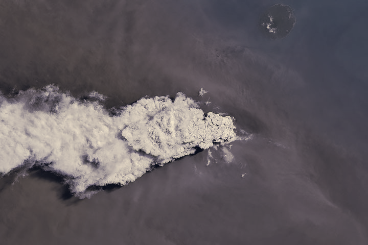
Satellites captured the eruption as it unfolded on September 5. Imagery from the Operational Land Imager on Landsat 8 shows a white gas plume rising above a brown ash cloud, while the Visible Infrared Imaging Radiometer Suite on Suomi NPP recorded the volcanic material dispersing over a wide area. Meteorological monitoring reported ash reaching altitudes up to 6,000 meters to the east of the vent and as high as 15,000 meters to the west by September 6.
Authorities temporarily shut several airports on the two islands as ash entered air routes, with operations resuming by September 8. The Indonesian Humanitarian Coordination Platform reported ashfall over populated zones to the east of Anak Krakatau, including Jakarta, and warned that volcanic ash can irritate the respiratory tract, eyes, and skin. The platform also distinguished volcanic ash hazards from the smoke produced by peatland fires, noting differences in particle properties, dispersal, and recommended protections.
The continuous explosive activity subsided on September 6, but the volcano continued to rumble and reverted to a more typical Strombolian pattern, marked by intermittent spurts of ash and volcanic material. Officials kept the volcano at the country’s second-highest alert level, a status it has held since early July, and monitoring remains intensive. Ongoing surveillance by remote sensors will determine whether further eruptions will force new disruptions to aviation and local air quality.